Dholera TP Zones Explained for Plot Buyers and Investors
Dholera TP zones are six Town Planning Schemes, TP 1 to TP 6, used to organise land development within the Dholera Special Investment Region (SIR) in Gujarat. They define how land is reorganised for roads, infrastructure and planned development, but do not independently determine what can be built on a plot.
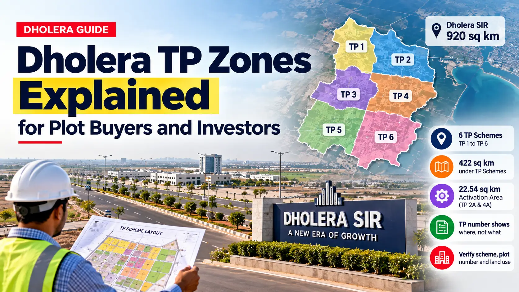
Dholera SIR covers approximately 920 sq km, while its six main TP schemes cover around 422 sq km. Each scheme includes different land use categories, infrastructure arrangements and planning requirements.
For plot buyers and investors, understanding these differences is important. A TP number alone cannot confirm whether land is residential, industrial, legally ready for construction or connected to essential infrastructure.
In Short
-
Dholera has six main Town Planning Schemes, TP 1 to TP 6, covering approximately 422 sq km.
-
The 22.54 sq km Activation Area includes portions of TP 2A and TP 4A.
-
A TP number identifies a planning area, while the Development Plan determines permitted land use.
-
Buyers should verify the scheme status, Final Plot number, ownership and land use before purchasing.
What Dholera TP Zones Actually Mean
A Town Planning Scheme is a statutory planning process that reorganises existing land parcels into planned plots with roads, utilities and public facilities. It is not a residential, commercial or industrial zoning classification.
In Gujarat, town planning schemes operate under the Gujarat Town Planning and Urban Development Act, 1976. The Dholera Special Investment Region Development Authority (DSIRDA) administers the relevant planning framework, subject to statutory approval procedures.
Under this process, existing landholdings are reorganised to accommodate roads, drainage systems, public infrastructure and other planned facilities. Landowners receive reconstituted plots according to the applicable scheme provisions.
The term Dholera TP zones is frequently used on property websites, but buyers should understand the difference between two planning concepts.
The Development Plan identifies permitted land use categories, such as residential, industrial, commercial, logistics, recreation and green spaces.
The Town Planning Scheme deals with plot reconstitution, road alignments, infrastructure reservations and the allocation of Final Plots.
For example, two properties within TP 2 may have different permitted uses. One could fall within a residential area, while another may be designated for industrial development or public facilities.
This distinction matters because buying land in a particular TP scheme does not automatically provide permission to construct a house, warehouse or commercial building.
How the Six Town Planning Schemes Differ
Dholera SIR has six principal Town Planning Schemes that divide the planned development area into manageable geographical sections. These schemes vary in size and contain smaller sub-schemes for detailed land planning.
TP 1 covers approximately 51.40 sq km, while TP 2 extends across 102.34 sq km, making it the largest principal scheme.
TP 3 covers around 66.60 sq km, and TP 4 covers approximately 60 sq km. TP 5 and TP 6 cover about 74.75 sq km and 67.33 sq km respectively.
Together, the six schemes account for approximately 422 sq km.
The planning framework groups these schemes into broader development phases. TP 1 and TP 2 form the first planned phase, TP 3 and TP 4 the second, and TP 5 and TP 6 the third.
However, a planned development phase should not be interpreted as a confirmed completion date for every road, utility or private plot.
Another important detail is the sub-scheme number. For example, TP 2 includes TP 2A and other subdivisions, which may have different statutory stages and plot arrangements.
When comparing properties, buyers should check the exact sub-scheme rather than relying only on labels such as TP 2 or TP 5.
Why the Dholera Activation Area Matters
The Dholera Activation Area is a 22.54 sq km priority development area where initial urban infrastructure investment has been concentrated. It lies within portions of TP 2 and TP 4, including the relevant TP 2A and TP 4A sub-schemes.
The area was planned to support early development through essential infrastructure such as roads, water supply, drainage, wastewater treatment and utility networks.
It represents a relatively small part of the larger Dholera SIR, making its geographical boundaries particularly important for property buyers.
The following table explains the main planning areas.
| Planning Area | Approximate Size | Key Detail |
|---|---|---|
| Dholera SIR | 920 sq km | Entire planned investment region |
| TP Schemes 1 to 6 | 422 sq km | Principal town planning area |
| Activation Area | 22.54 sq km | Priority infrastructure development area |
| TP 2 and TP 4 | 162.34 sq km | Principal schemes containing the Activation Area |
A common misunderstanding is that every plot in TP 2 or TP 4 automatically falls within the Activation Area.
This is incorrect because the Activation Area occupies only selected portions of these larger schemes.
Buyers should also distinguish between nearby infrastructure and actual plot connectivity. A property may be close to a planned road or utility corridor without having direct access to the service.
Before purchasing, confirm the plot's location, road access, utility availability and any additional site preparation requirements.
How Original and Final Plots Affect Buyers
An Original Plot (OP) is the landholding identified before town planning readjustment, while a Final Plot (FP) is the reconstituted parcel identified through the scheme. Their area, shape and location may differ.
Town planning schemes require land to be reorganised for roads, utilities, public facilities and other planned infrastructure.
As part of this process, a landowner's original holding may be adjusted, with a reconstituted plot allocated under the applicable statutory provisions.
This means the Final Plot may not have exactly the same boundaries or area as the original agricultural parcel.
For buyers, the difference becomes particularly important when a seller advertises land using an original survey number but shows a proposed Final Plot on a marketing layout.
The relevant records should establish a clear connection between the original holding and the Final Plot being offered.
Buyers should verify the Original Plot number, Final Plot number, plot area, boundaries and scheme approval status.
Another often-overlooked detail is whether any town planning contributions or other statutory liabilities apply to the property.
These obligations may affect the total acquisition cost even when the quoted land price appears attractive.
A plot shown on a draft plan should not automatically be treated as having settled boundaries or final development permissions.
How to Verify Your Plot Before Buying
To verify a plot in Dholera, begin with its survey number and village name, then compare these details with official land records and planning documents. A brochure or unofficial layout should never be the only basis for a purchase decision.
Follow these practical steps before paying a booking amount.
-
Collect the land details. Obtain the village name, survey or block number, land area and ownership documents from the seller.
-
Verify ownership records. Check the relevant Gujarat land revenue records, including ownership entries, mutation history and recorded land classification.
-
Confirm the TP scheme. Identify the exact scheme and sub-scheme through DSIRDA planning records.
-
Check the Final Plot details. Verify the officially recorded plot number, area, boundaries and connection with the original landholding.
-
Review the permitted land use. Confirm whether the intended residential, commercial or industrial development is allowed under the applicable Development Plan and regulations.
-
Examine restrictions and approvals. Check for road reservations, environmental restrictions, applicable land-use permissions and building approval requirements.
-
Assess infrastructure and costs. Verify road access, drainage, electricity, water supply and any necessary earth filling or site preparation.
Buyers should also consider an independent legal review of the title chain, encumbrances and statutory planning documents.
These checks are especially important because land ownership, planning approval and construction permission are separate matters.
Common Mistakes to Avoid When Buying Land
The biggest mistake buyers make is assuming that a TP number confirms a property's land use, legal status and development readiness. Each of these factors requires separate verification.
Several other mistakes can affect a purchase decision.
Relying on unofficial maps: Property advertisements may use conceptual or outdated layouts. Buyers should compare them with the applicable statutory scheme documents.
Ignoring the sub-scheme: Different subdivisions within the same TP scheme may have different planning stages and Final Plot arrangements.
Confusing proposed roads with usable access: A planned road does not necessarily mean a property currently has direct, legally established road access.
Overlooking development costs: Earth filling, drainage, utility connections and statutory approvals can increase the total cost of preparing a site.
Assuming every Final Plot is construction-ready: A recorded Final Plot number does not automatically establish that every building permission has been obtained.
Depending on future price predictions: Infrastructure development and investment announcements do not establish how much a particular plot will appreciate.
A more practical approach is to compare properties based on verified ownership, permitted land use, scheme status, infrastructure availability and total development costs.
Understanding Dholera TP zones helps buyers focus on these measurable factors rather than promotional descriptions.
Frequently Asked Questions
How many TP schemes are there in Dholera?
Dholera SIR has six principal Town Planning Schemes, TP 1 to TP 6, covering approximately 422 sq km.
Which TP schemes include the Activation Area?
The 22.54 sq km Activation Area lies within portions of TP 2 and TP 4, including the relevant sub-schemes.
Does a TP number determine residential land use?
No, the Development Plan and applicable regulations determine permitted land use, while TP schemes address plot reconstitution and infrastructure planning.
How can buyers verify a Dholera Final Plot?
Buyers should match survey numbers, ownership records and Final Plot details with official DSIRDA documents and applicable land revenue records.
Conclusion
Understanding Dholera TP zones helps buyers make informed property decisions by identifying the difference between planning areas and permitted land use. Before investing, verify the scheme status, Final Plot details, ownership and infrastructure through official records. Stay connected with Dholera News for reliable updates on Dholera's planning and development.